

Total-Station-Surveying-Precision
Have you ever wondered how engineers and contractors accurately determine precise site locations?
The answer lies in using advanced surveying tools like the Total Station. In this article, we’ll explore how this technology transforms construction projects.
Key Takeaways:
Total Station surveying increases accuracy in positioning.
Minimizes human error in construction.
Saves time and effort in field operations.
Used in infrastructure, architectural, and industrial projects.
Offers high precision in distance and angle measurements.
Total Station surveying increases accuracy in positioning.
Minimizes human error in construction.
Saves time and effort in field operations.
Used in infrastructure, architectural, and industrial projects.
Offers high precision in distance and angle measurements.
What is Land Surveying and Why Does It Matter?
Land surveying is a crucial step in project planning across Saudi Arabia. It involves measuring and mapping land using advanced tools to ensure precision. This process allows for accurate positioning, effective planning, and safe implementation.
Types of Surveying:
Geodetic Surveying
Topographic Surveying
Detail Surveying
Geodetic Surveying
Topographic Surveying
Detail Surveying
Each type serves specific roles in engineering, from terrain mapping to site analysis.
Importance in Engineering Projects:
Accurate site location for construction.
Planning of roads, bridges, and infrastructure.
Evaluating topography and elevation.
Accurate site location for construction.
Planning of roads, bridges, and infrastructure.
Evaluating topography and elevation.
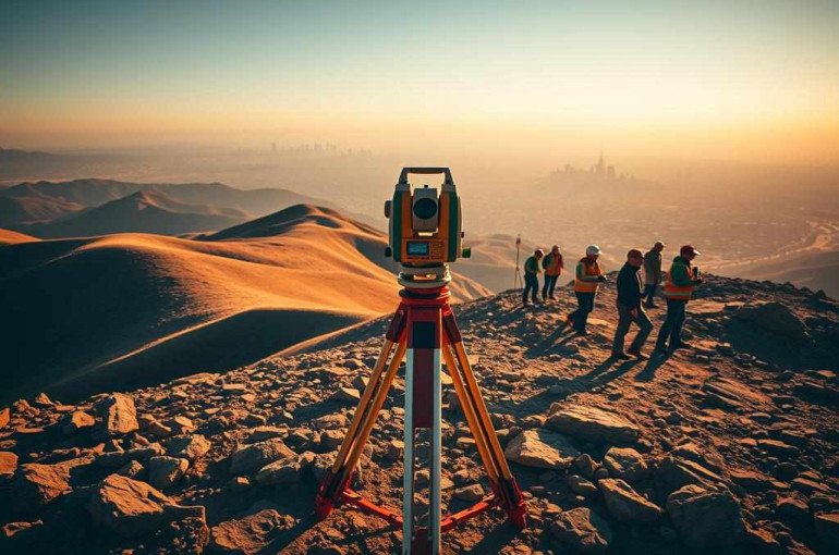
What is a Total Station & How Does It Work?
A Total Station is a modern surveying instrument combining electronic theodolites and distance meters. It measures angles and distances with high precision and stores the data digitally for further processing.
Main Components:
Electronic Theodolite – measures horizontal and vertical angles.
Electronic Distance Measurement (EDM) – calculates distances using laser or infrared.
Data Processor – processes and stores measurements.
Display Interface – allows real-time data visualization.
Electronic Theodolite – measures horizontal and vertical angles.
Electronic Distance Measurement (EDM) – calculates distances using laser or infrared.
Data Processor – processes and stores measurements.
Display Interface – allows real-time data visualization.
How It Works:
A laser beam is directed toward a prism (reflector) or directly to a target. The time it takes for the beam to reflect back is used to calculate distance, while angle sensors track the orientation.
Advantages of Total Station Surveying
Compared to traditional surveying tools, Total Stations offer:
Extremely high measurement accuracy.
Speed in data collection.
Reduction in human error via digital recording.
Compatibility with harsh environments.
Direct data transfer to computer systems for analysis.
Types of Total Stations Available in Saudi Arabia
Multiple global brands offer a wide range of Total Stations for the Saudi market:
Leica – Offers precision and advanced tracking technologies.
Topcon – Known for fast, user-friendly systems (e.g., ES series).
Trimble – Offers powerful features in the S Series.
Sokkia – Reliable devices with strong performance (e.g., FX series).
Stonex – Affordable solutions for various survey needs.
Required Tools & Accessories for Total Station Surveying
You’ll need:
Tripod Stand – for stable installation.
Prisms – reflect laser beams for accurate distance measurement.
Glass prisms for accuracy
Metal prisms for durability
Battery Packs, Chargers, and Carry Cases
Water Level & Measuring Tape
PDA or Laptop – to store and analyze data.
Setting Up the Total Station
Steps:
Mounting on Tripod – Ensure it's stable and level.
Leveling the Device – Use built-in leveling tools for calibration.
Initial Configuration – Set units and calibration preferences.
Align to Control Points – Identify benchmarks for consistent positioning.
Mounting on Tripod – Ensure it's stable and level.
Leveling the Device – Use built-in leveling tools for calibration.
Initial Configuration – Set units and calibration preferences.
Align to Control Points – Identify benchmarks for consistent positioning.
How to Conduct a Total Station Survey
Define Control Points – Using GPS or traditional benchmarks.
Place the Prism – Strategically for accurate line-of-sight measurements.
Measure Coordinates – Record angles and distances.
Data Logging – Save all measurements for processing.
Define Control Points – Using GPS or traditional benchmarks.
Place the Prism – Strategically for accurate line-of-sight measurements.
Measure Coordinates – Record angles and distances.
Data Logging – Save all measurements for processing.
You can use:
Prism-based surveying
Reflectorless measurement
Advanced techniques like RTK
Data Processing After Field Survey
After fieldwork, process data to generate maps and engineering models.
Steps:
Transfer Data – via USB, memory card, or wireless.
Use Specialized Software :
Leica GeoMoS
Trimble Business Center
Sokkia Spectrum Survey
Create Maps and Layouts using AutoCAD or similar software.
Transfer Data – via USB, memory card, or wireless.
Use Specialized Software :
Leica GeoMoS
Trimble Business Center
Sokkia Spectrum Survey
Create Maps and Layouts using AutoCAD or similar software.
Common Mistakes & How to Avoid Them
Improper Device Leveling – leads to inaccurate readings.
Unstable Tripod or Prism Setup – causes data inconsistencies.
Data Entry Errors – always double-check entries.
Incorrect Reference Points – leads to displacement in project layout.
Improper Device Leveling – leads to inaccurate readings.
Unstable Tripod or Prism Setup – causes data inconsistencies.
Data Entry Errors – always double-check entries.
Incorrect Reference Points – leads to displacement in project layout.
Ensure training and protocol adherence to minimize these risks.
Applications of Total Station Surveying in Saudi Projects
Infrastructure Projects:
Road and bridge design
Drainage and water networks
Power substation placement
Road and bridge design
Drainage and water networks
Power substation placement
Real Estate & Building Construction:
Boundary definition
Engineering design layout
Construction progress monitoring
Boundary definition
Engineering design layout
Construction progress monitoring
Industrial & Mining:
Mine location planning
Terrain monitoring
Industrial site mapping
Mine location planning
Terrain monitoring
Industrial site mapping
Conclusion
Total Station surveying plays a pivotal role in engineering and construction across Saudi Arabia. It provides unmatched precision, speed, and reliability.
Whether you're mapping land, planning a large infrastructure project, or ensuring a building aligns with its blueprint, the Total Station ensures your data is accurate and actionable.
📞 Need expert land surveying? Contact us at 0562274361.
Frequently Asked Questions (FAQ)
What is a Total Station?
A Total Station is an electronic instrument used in surveying to measure angles and distances accurately.
Why is Total Station surveying important in engineering?
It ensures precise site layout, minimizes errors, and improves project efficiency.
Which brands offer Total Stations in Saudi Arabia?
Popular brands include Leica, Topcon, Trimble, Sokkia, and Stonex.
What tools are required for Total Station surveying?
Besides the Total Station, you need tripods, prisms, batteries, and data processors.
How do I set up a Total Station?
Install it on a tripod, level it, and input necessary calibration settings before use.
How is survey data processed?
Data is transferred to software like AutoCAD or Trimble for mapping and analysis.
What are common errors in Total Station surveys?
Improper leveling, unstable setup, and incorrect data logging are most common.
Where is this technology used in Saudi Arabia?
It is widely used in infrastructure, real estate, and industrial site planning.